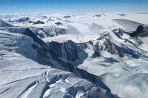
Operation Ice BridgeNASA’s Operation IceBridge images Earth’s polar ice in unprecedented detail to better understand processes that connect the polar regions with the global climate system. IceBridge utilizes a highly specialized fleet of research aircraft and the most sophisticated suite of innovative science instruments ever assembled to characterize annual changes in thickness of sea ice, glaciers, and ice sheets. In addition, IceBridge collects critical data used to predict the response of earth’s polar ice to climate change and resulting sea-level rise. IceBridge also helps bridge the gap in polar observations between NASA’s ICESat satellite missions.Geophysical Institute at the University of Alaska FairbanksIn the next 200 years, the ice sheet model shows that melting at the present rate could contribute up to 63 inches to global sea level rise, said the team led by scientists at the Geophysical Institute at the University of Alaska Fairbanks. This new estimate is 80 percent higher than previous estimates, which forecasted up to 35 inches of sea level rise from Greenland’s ice. A Clearer PictureIceBridge’s detailed ice thickness measurements helped the team to be the first to model these areas where outlet glaciers are affected by warmer ocean waters, as well as to model more of the complex feedbacks and processes influencing ice loss than previously possible. They examined the importance of factors like underwater melting, large ice chunks breaking off of glaciers, changing snowfall rates and rising air temperatures. They also examined factors that could slow down ice loss, like the movement of Earth’s surface “bouncing back” from the weight of ice that is no longer there.
Operation Ice Bridge